Environmental and Social Impact Assessment
Client: The World Bank / GEF International Waters Portfolio –
Team members: Nicholas Hodgson (theNRgroup); Roy Hagen (Independent Consultant); Amadou Konare (World Bank)
Time: 2001
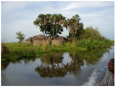
Lake Chad is Africa’s fourth largest lake, the largest in Western and Central Africa. Wetlands and floodplains extend outward from the lake itself, expanding the basin to the second largest wetland in sub-Saharan Africa. The effective basin provides a key freshwater source shared by Cameroon, the Central African Republic (CAR), Chad, The lake is shallow, with an average depth of 1.5 meters.
 The surface area of the lake varies considerably, from 25,000 square kilometers to a low of 2,500 in the past 30 years. This is primarily a result of the persistent decline in rainfall over the whole of the basin. Close to 20 million people rely on lake-based economic activities. The lake, its floodplains, and surrounding wetlands support recessional agriculture, pastoralism, forest regeneration, fish breeding and production, and limited tourism. The basin has also been identified as supporting biodiversity of global significance, with numerous bird species relying on the lake for sustenance during periods of migration.
The Lake Chad Basin Commission has requested a grant of $10 million to develop a Strategic Action Programme and implement six pilot projects within the Lake Chad Basin.
The objectives of the Environmental and Social Assessment (EA/SA) were to identify, qualify, and to the extent possible, quantify the likely negative and positive environmental and social impacts of the project as presently designed, and to propose the mitigating measures to avoid negative impacts. The overall objective was to enhance the quality and sustainability of the project, and to ensure that the project is in compliance with the World Bank’s Safeguard Policies and Quality At Entry requirements.
 The study showed that there were no significant negative environmental or social impacts expected. However, many of the pilot proposals focused on further community planning initiatives, with few on-the-ground interventions, and as a result risk social impacts related to the loss of community support and motivation. The study recommended initiating community based development interventions as a high priority component of the pilot projects.
There was one unforeseen issue. Under the Operational Policy 4.37 on Dam Safety, the condition of the Maga Dam which lies upstream of the Waza Logone Pilot Project area is an issue that needs further investigation. During peak flood, the dam spillway flows from the river into the reservoir, while the main discharge channels have silted and are unable to take the design releases, the dam wall is eroding and there are cases of piping, threatening both Maga town in the irrigation scheme and populations in the downstream flood plains.