Client: Nippon Koei / JBIC
Lead expert for EIA component: K. Campbell (theNRgroup)
Time: TBC
The Brantas River basin is the most urbanised region in Indonesia and the Brantas River is the largest river system in East Java. The basin contains most of East Java’s water reservoir capacity and produces about ten per cent of the nation’s rice crop. The demand for water in the region is escalating whilst, at the same time, water quality is coming under increasing pressure from industry, agriculture and urbanisation. Five multipurpose hydropower reservoirs and several other water resources infrastructures (barrages, levees, irrigation canals etc) have been built during the last four decades in this catchment.
Genteng Dam was proposed as a multipurpose project and integral component of water development in Brantas River basin. The objectives of the Genteng Project were:
- To supply domestic and industrial raw water to Surabaya and its vicinity
- Hydropower generation utilizing the reservoir releases plan
- Flood control for the downstream area of the Genteng river
Of these, the highest priority was water supply. The proposed reservoir, situated in the upper catchment, was designed to store water during the wet season and to release during the dry season – increasing available water supplies downstream. Water release would generate hydropower.
Diversion of water from the Juwok, Grangsil and Manjing Rivers in adjoining basis into the Genteng catchment was a feature of the original proposals formulated by the Master Plan Study in completed in 1985. These potential river diversions were also included within the scope of the EIA.
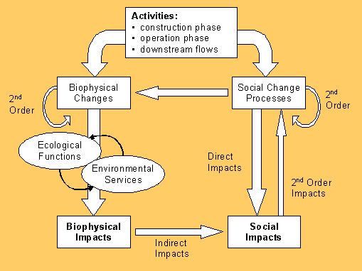
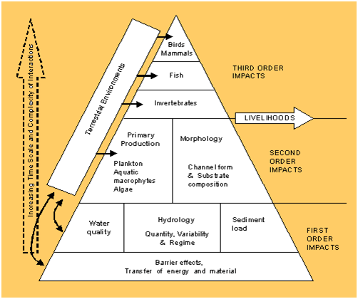
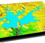
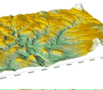
The framework adopted for impact assessment involved examination of (i) first order, (ii) second order, and (iii) third order direct and indirect impacts in relation to upstream and downstream impact areas. Direct impacts from reservoir impoundment were related to the flooding of the reservoir, locations of construction activities and related sites, and to the modified river flows. The spatial extent and magnitude of these direct impacts were assessed with the aid of hydrological flow records, detailed digital terrain models and an extensive GIS database created by the EIA component of the feasibility study. By contrast, indirect impacts were more difficult to define, both in terms of the nature and magnitude of impact and their spatial extent, as well as the time scale during which impacts may be felt. Impacts as a result of potential changes in water quality were able to refer to new published regulations relating to risks from contamination of water supplies.
- Impacts on land use in the proposed catchment.
- The proposed reservoir area – conversion of land use, extent of compensation, and impacts from the reservoir itself, including potentially serious issues relating to water quality.
- Impacts during construction and impoundment phases
- Impacts during operation
- Downstream impacts, including greatly reduced wet season water flows, changes in sediment release and the potential from changes to river morphology.
- Impacts on upstream and downstream water supplies and water quality, and the risks from increased levels of pollution (e.g. from tapioca processing, organic matter and sewage, and chemical content including compounds such as mercury)
- Fish species diversity and fisheries development
- Potential Social Impacts in reservoir area and in downstream areas. These studies included a series of public consultation meetings for which the GIS provided important material
Geographic Information Systems
Geographic Information System (GIS) and other spatial analytical techniques were important tools used during the Environmental Impact Assessment.
Fisheries

Existing reservoirs and barrages coupled with pollution of waterways and introduction of exotic species has resulted in significant reduciton in native aquatic species
Possible mitigation included alternatives to dam construction. Improved demand side management of water supplies was examined. This is increasingly on the agenda in regions where concerns have arisen over water sufficiency, allocation, and high costs of expanding supplies, as well as environmental preservation. Mitigation was examined during (i) the construction phase, (ii) the impoundment phase, and (iii) the operational phase. This latter included issues relating to:
- Downstream water release and Environmental Flow Requirements
- Erosion in the draw-down zone
- Changes in water quality (nutrient loading, biological waste and pollutants)
- Accumulation of sediment in the reservoir
- Fish species conservation and the development of reservoir fisheries
- Modified stream flow
- Compensation as mitigation for damaged environment
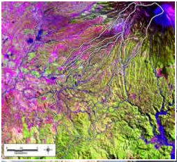
Portion of Landsat TM image. Bands 5,4,3: overlain with major drainage lines and catchment area boundary.
Areas with dominant land cover of healthy growing vegetation are seen as green. Areas with significant cover of buildings (settled areas) and of bare soil (harvested fields and land with sparse vegetation cover) are seen as magenta / meganta. Patches of blue and grey-blue colour in the West and North-west of the image represent flooded rice paddy (young plants with significant area of open water visible). Adjacent patches of homogenous bright green represent mature rice paddy. Patches of blue-green represent sugarcane. The extent of forest clearance in Grangsil and Juwok catchments is indicated by extensive areas of purple / magenta. In Genteng catchment, ribbons of settlement (buildings and associated cultivation) can be seen extending to the highest elevations within the catchment. In this image, the volcanic cone of Mt. Semeru is clearly visible and seen as grey-blue with tinges of purple. Sediments derived from these volcanic deposits are clearly seen towards the South-east of the image in the flat and low-lying estuary of the Manjing River.