Client: ERM-Environmental Resources Management
Donor: DFID – Department for International Development
Team Leader: Stephane Flasse
Time: 2002
In 1994, a detailed survey of forest areas in Cross River State (CRS) was completed with support from the then UK-Overseas Development Administration (ODA). The 1994 survey produced a state-wide map of forest types and provided information on both the likely volume of timber available for harvest within CRS, and sustainable rates of harvest. In 2002 DFID requested a rapid exercise to update the inventory. This update was carried out by an NRgroup team led by Stephane Flasse.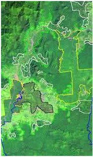
The assessment relied on the analysis of satellite imagery and had as its focus an update of the forest extent and distribution, and an update of the overall timber volume.
To satisfy the rapid nature of this update assessment, the work relied on the use of Landsat ETM imagery of 2001, providing a spatial resolution of 30 meters. Images were analysed both visually and with image processing techniques to extract the current distribution and status of the forest in CRS.
 Ground control work was carried out during three days of spot- checking to ensure an appropriate and homogeneous interpretation of the imagery. The plots’ information from the 1994 inventory was also used in conjunction with the satellite imagery.
This project provided a vegetation map update,an assessment of forest change (location and extent), as well as of timber volume.